Use QGIS to generate contour lines from a DEM
This guide will help those who have used ESRI software in the past to create countour line datasets. Instead of spending big bucks on ArcDesktop and the Spatial Analyst you can do this for free with QGIS.
The first step is to load your DEM data. QGIS uses GDAL to handle raster datasets, and GDAL can load almost every format out there. Seriously, GDAL is awesome. Once you have loaded your data make sure it is in the correct projection by right clicking the layer in the table of contents, the select Set Layer CRS. You’ll also want to set the project to your layer’s CRS, you can either use the Set Project to Layer CRS in the same menu, or go to File, Project Properties, and click the Coordinate Reference System tab.
In other GIS software your DEM may automatically be drawn with a grayscale or colormap already set. In QGIS by default you’ll only see a gray rectangle.
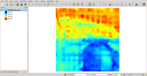
On the style tab of the layer properties menu you can select how you want your raster to be symbolized. Here’s the same layer displayed with elevations represented by pseudocolors:
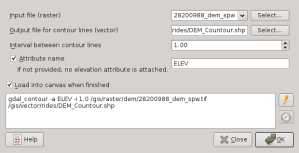
To generate contours click Raster, then Extraction, then select the Contour menu.
The menu is pretty self explanatory. It is a front end for the gdal_contour command line tool. You can use the generated command at the bottom as the starting point for a batch file if you have several files you need to convert.
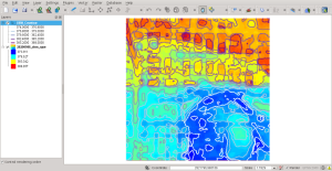
Easy peasy!


Awesome, Thanks!
Perfect. Only a little update, QGIS 2.8 can display directly the colours of DEM and the Extraction runs well and fast also with gray scale DEM if you have anyone.
Great tip. I was delighted to find out it created a shp file. How can I add the elevation of the contour into the field value? I want to be able to bring the 3D contours into another program. Thanks.
Check the Attribute Name box. By default the field will be named “ELEV” but you can change it if you like.
Can you get contours on a photo using QGIS?